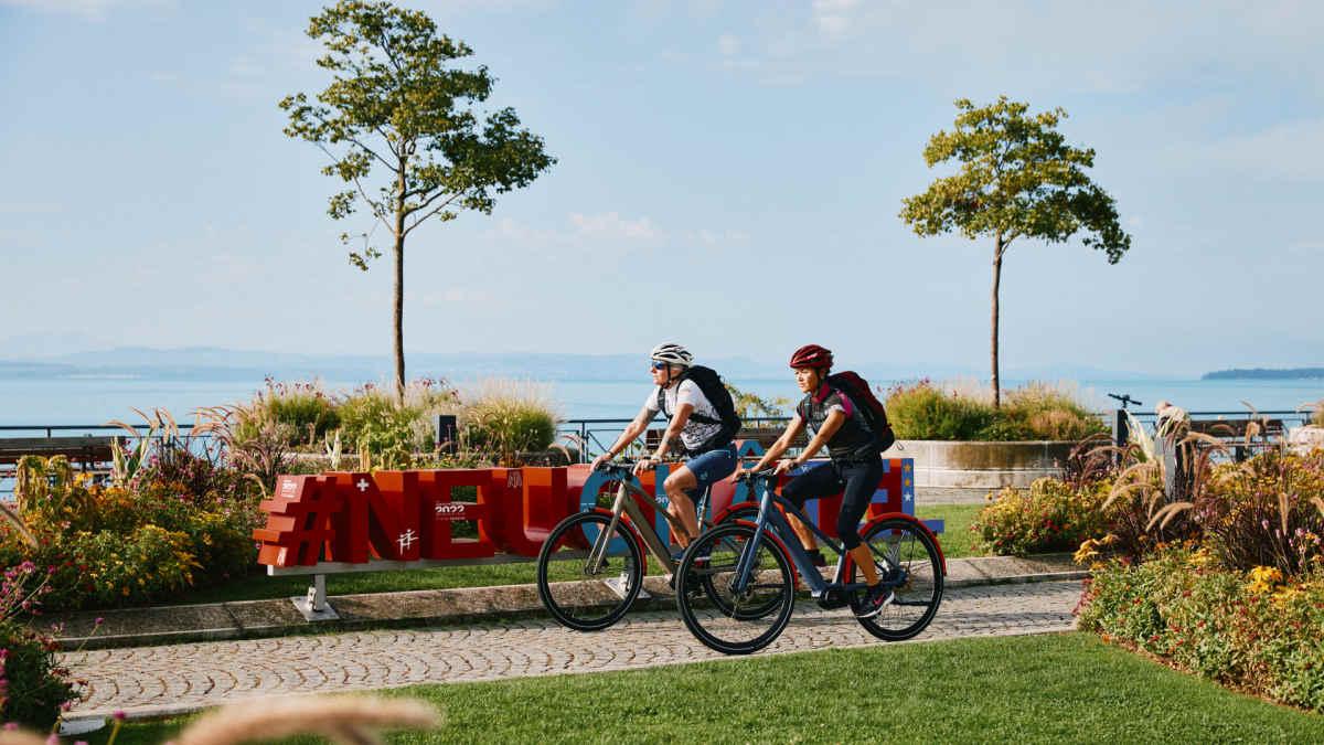
Glacier E-Bike Tour: Spectacular Alpine crossing from St. Moritz to Zermatt
Thomas Rögner
· 22.05.2026


Snow white, deep turquoise, steel blue and always bright red. This e-bike tour through the heart of Switzerland in the footsteps of the famous Glacier Express is colourful and varied. You will be challenged at the start and then flattened - by the panoramic views, the mountain passes over 2000 metres high and the roaring descents.
Probably the slowest express train in the world was born in Switzerland almost a hundred years ago and has been world-famous ever since, thanks in part to its striking red carriages. Its original purpose: to connect the then already famous winter sports resorts of St. Moritz and Zermatt and thus make them even more popular. Mission accomplished, I would say. But what if you wanted to explore the striking mountains and glaciers, endless valleys with turquoise-coloured rivers and lakes, the heart of Switzerland, even more slowly and enjoyably? Quite simple: follow the tracks of the Glacier Express on two tyres, in the saddle of an e-bike. A pleasure tour designed by meticulous Swiss tourism experts, on which you can explore the scenic and cultural highlights of Switzerland in up to ten stages. The bare figures already reveal the character of this "Glacier Bike Tour" project. In less than 400 kilometres (370 to be precise), there are almost 10,000 metres of ascent. Well, 9500 metres of ascent add up, which is why the ten pre-planned stages and a powerful e-bike with sufficient battery capacity make sense. I'll tell you up front: I've never experienced the excess of passes and bends and hairpin bends and summit views that I did over the ten days. And that's despite the fact that I've already crossed the Alps fifty times on my bike. Oh yes, and don't be surprised to experience totally unexpected encounters. With a crocodile, for example. Or a lighthouse. Not on the water, but up on the mountain. But more on that later.
One piz next to the other
I meet up with Marc Woodtli from "Graubünden Ferien" and his partner Judith at the Rhaetian Railway station in St. Moritz to get things off to a good start. Sophisticated is the middle name of this mountain resort, once the summer holiday destination of wealthy Europeans. With a base altitude of over 1800 metres and the Maloja wind blowing frequently and strongly, temperatures are never too high in summer. If you don't like the swanky hotel buildings, simply move on to tranquil, car-free Sils, on the lake of the same name. This is where Friedrich Nietzsche sought and found secluded spots in nature and inspiration for his philosophical works. After a briefing about the day's route ahead and the best photo spots, we set off. As Marc has mapped out the route himself and has of course already cycled all of it, I don't need to activate my Garmin on the handlebars or Google Maps. A talking live guide with tonnes of additional knowledge in his active memory is simply unbeatable. Just a few metres above and next to the striking Lake Moritz are other bathing and excursion lakes in shady larch forests. Not far away, striking white-capped glaciers rise up, all bearing the first name Piz: Piz Palü, Piz Bernina, Piz Corvatsch or the sweeping Morteratsch glacier, which towers behind the railway station of the same name. However, we set off in the opposite direction - along the Inn, or "En" in Rhaeto-Romanic, which gives the Engadin its name. "You immediately feel like you're in a different world here," says Marc as we roll along the vigorously bubbling river towards Austria, which meanders between lush meadows and rugged gravel banks. I can't disagree. The pleasurable downstream roll comes to an end in La-Punt. Between graffiti-decorated houses, I turn 90 degrees to the left and - bang - the first hairpin bends of the Albula Pass are approaching. For once, I'm happy about the clearly audible whirring of my motor, because it makes it clear how well it's pushing along. The classic black and white sign greets us on the pass with the altitude: 2315 metres. Wow. And that on the first day of the tour. Marc's recommendation over breakfast coffee now makes sense: if you're travelling from the lowlands, you should perhaps even plan an acclimatisation day in the Engadin. And a second piece of advice will prove important later on. E-bikes and riders should be suitable for gravel and even trails. This is because some kilometres of the route run through nature, on unpaved paths and even on trails, narrow paths under and over slopes. Practised off-road riding, a good sense of balance and stable self-confidence in your luggage will help immensely. On the descent from the pass, the helical tunnels and high viaducts of the Albula line look like a model railway landscape. This section of the Glacier Express is even classified as a UNESCO World Heritage Site. The destination of the first stage is Bergün, the setting for Heidi films, at an altitude of around 1400 metres. The Albula Railway Museum and an exotic encounter with a supposed pangolin await at the station: the RhB 407 locomotive is affectionately known as the "crocodile" due to its design and you can experience the journey from a crocodile tamer's perspective in the integrated simulator. Pure nature and a kingdom await on the next section: the "Bike Kingdom", an elaborately developed touring and trail paradise for mountain bikers, lies at the end of the second stage around Lenzerheide. Here, slightly thicker tyres with tread prove their worth, as we test the last few metres on the St. Cassian single trail. This day is also scratching the 1000 metre altitude mark, as we wind our way out of the Albula Valley up to the mountain villages of Brienz and Lantsch to reach Lenzerheide.
From the Rhine to the Via Mala
The changes, the different regions that you experience on this east-west route through Switzerland are fascinating and exciting. After the mountainous start, I am surprised by the mild temperatures that greet us around Domleschg and before the stage town of Thusis. However, we also enjoyed 1400 metres of descent and arrived in the orchard of Graubünden. Over 150 varieties of apple, pear, apricot and peach trees speak for themselves. Unfortunately, almost everything has already been harvested, but at Casa Caminada in Fürstenau there are delicious croissants with fillings. Why do they taste so good? Well, when a Michelin-starred chef like Andreas Caminada wants to make something really delicious, an oven is specially built to historical specifications. And the star chef has kept his feet firmly on the ground, as I discover in a brief conversation. Marc and Andreas know each other "by chance", of course. And Marc has two more unusual places with a special atmosphere in store for me. Story Thusis is a shop-co-working-café-lodge-lounge project whose windows look out onto the famous Via Mala gorge. If you have time, you should definitely take a look inside - both the lodge, which offers cyclists a great service and even self-wrenching stations. And into the oppressively attractive Via Mala gorge, which gave its name to a novel and German TV three-parter starring Mario Adorf in the 1980s. Originally, the "Schlechte Weg" was an important connection via Thusis to the Splügen and San Bernardino Passes. The Rhine, probably the most formative river in Europe, originates from several "Rheins", the Vorderrhein flows through Thusis and we work our way up to the source over the next few days. Really high, because the source of this mighty river lies at an altitude of 2344 metres. And not far from there, on the Oberalp Pass, we solve the riddle of the lighthouse - the only one in the whole of Switzerland, by the way. And perhaps the only lighthouse with its own website. Here is the short version: "The lighthouse comes from Rotterdam. Its original is in the Maritime Museum. It once stood in Hoek van Holland at the mouth of the Rhine into the sea. The lighthouse on the Oberalp Pass stands at the source of the Rhine." A ship should be added, but we are still waiting for it. And some people say the Swiss have no sense of humour. So the striking walk-in tower symbolises the cycle from creation to dissolution. With the Oberalp Pass, you conquer Switzerland's second legendary Alpine pass on the Glacier route. As with the Albula and the final Furka Pass, you should try not to tackle it at the weekend. Otherwise you will find yourself surrounded by crowds of motorbikes, convertibles, vintage cars, motorhomes and "I-love-this-awesome-car-brand-club-excursions", especially during holiday periods. We roll down to Andermatt along the cosy Oberalpsee lake, actually in close proximity to the red express train carriages. The countless hairpin bends almost make you dizzy and, depending on the load, the disc brakes are almost pushed to their limits. The Ursern Valley, where we land after the wild descent, is a hub of mountain passes in all four directions. The Gotthard Pass, which leads to the southern part of Switzerland, Ticino, is of course famous and legendary.
Photo happiness on the Devil's Bridge
Marc's conspiratorial smile makes me look up as he announces a photo highlight: "There's the Devil's Bridge in the Schöllenen Gorge and the railway tunnel runs through the mountain above. I hope you have a good wide-angle lens with you - with luck we'll get a great shot." He didn't promise too much. After just ten minutes, we manage the coordinative happening: touring bikers on a bridge over a roaring stream, above a red railway in front of a jagged grey rock face. The Glacier Bike Route also passes through three Swiss cantons, one of which everyone probably knows from crossword puzzles: Uri. We have now reached it with this 7th stage. The highlights such as Furka and the striking destination of Zermatt with the Matterhorn still await us. We approach the highest point from the east: 2429 metres above sea level, with almost 900 metres in altitude in between. The reward on the descent from the Furka Pass is the view of the white Bernese and Valais Alps with their sugared four-thousand metre peaks. And there's another one of those unexpected climatic and regional changes. The Valais welcomes us with rows of green vines, often protected by blue plastic nets. In Visp, almost all of the Swiss grape varieties can be tasted. In view of the expected final stage with over a thousand metres of ascent, I leave it at two deci of white wine on the penultimate evening to be on the safe side. At breakfast on the final day, the anxious question: will we see the legendary Matterhorn? Of course, we recognise the angular peak from countless photos. As it turns out, Judith and I have something in common. Neither of us has ever seen the Matterhorn in the flesh - and that, at least according to Marc, is something you have to experience once in your life. You wouldn't be truly Swiss without having seen the Matterhorn, he teases Judith. The weather is kind to us. Although a persistent cloud creeps around the edges of the Matterhorn, it is easy to see and can be recognised in the "proof photos". We treat ourselves to an extra tour with turbo support up to the middle station of the cable car and enjoy a last afternoon snack with a view of the 4478 metre high peak - with rösti, of course. It's almost a shame that it's over. Above all, I really enjoyed these landscapes, the changes, the impressions, the views, the little villages and the really delicious food. The slowest express journey of my life.
Tour data Glacier Bike Route
At this point, you will find external content that complements the article. You can display and hide it with a click.
Ten stages are planned, which can also be changed. With a minimum 630 Wh-hour battery, all stages should be possible without recharging. With the estimated journey time of 3 to 4 hours per day, there is enough time for culture and sightseeing on site, as well as for food and coffee breaks. In bad weather or depending on your mood, you can also cover intermediate sections on the Glacier Express. Here is the itinerary:
1st St. Moritz - Bergün, 36 km / 650 m altitude difference
2nd Bergün - Lenzerheide, 37 km / 850 m altitude difference
3rd Lenzerheide - Thusis, 33 km / 690 m altitude difference
4. Thusis - Bonaduz, 33 km / 1200 m altitude difference
5th Bonaduz - Ilanz, 38 km / 1200 m altitude difference
6th Ilanz - Disentis, 32 km / 600 m altitude difference
7th Disentis - Andermatt, 37 km / 1240 m altitude difference
8. Andermatt - Ulrichen, 45 km / 1030 m altitude difference
9. Ulrichen - Visp, 60 km / 430 m altitude difference
10th Visp - Zermatt, 39 km / 1150 m altitude difference
General info & travel tips
Journey
The starting point of St. Moritz can be reached by Rhaetian Railway via Chur. By car, you can either drive through the Engadin (via Innsbruck and Pfunds) or across Lake Constance to Chur and on to St. Moritz.
Worth seeing and remarkable
There are some cultural and scenic highlights along the way.
- The Albula Railway Museum is a must for railway fans.
- A detour to the 65 metre high Landwasser Viaduct near Filisur (day 2) with its six arches.
- The concrete house of the writer Linard Bardill and the oldest lime tree in Switzerland (800 years old) in Scharans (day 3).
- The Via Mala gorge near Thusis.
- Confluence of the Anterior and Posterior Rhine in Reichenau (day 4).
- Valendas with the largest wooden fountain in Europe, old town and Museum Regiunal Surselva in Ilanz (day 5).
- The Autra Caussa, Switzerland's first street art hotel in Danis/Dorf and the Benedictine monastery in Disentis (day 6)
- The striking lighthouse from Rotterdam stands on the Oberalp Pass, and if you want to see the source of the Rhine, hike up to Lake Toma at 2344 metres - this is the source (stage 7).
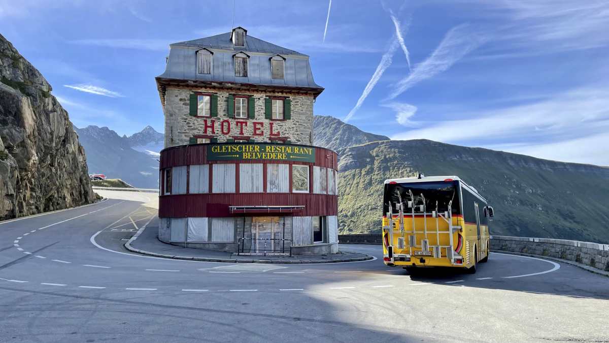
- The historic Furka steam railway can be admired on the ascent to the pass of the same name, which Goethe crossed in deep snow in 1779 (day 8).
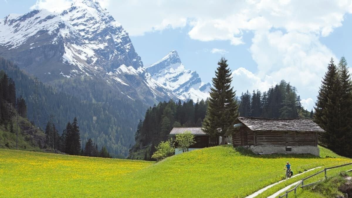
- Valais is the largest wine region in Switzerland. On the way there, you pass Obergoms with the oldest wooden buildings in the country, including Mühlebach with its wooden houses on the "Mäuseplatten" (day 9).
- The Matterhorn is the last four-thousand-metre peak in Europe to be climbed and was tragically conquered for the first time. Four men from Edward Whymper's rope team fell fatally in 1865.
Accommodation
The Glacier Bike Tour website provides tips and links to local accommodation. Here are a few unusual places to stay along the route, either because they are historic, have a special charm or offer a special ambience. The numbers stand for the day's stage:
- Parkhotel Margna near Sils (1),
- the Kurhaus Bergün (3)
- Hotel Weiss Kreuz in Thusis,
- the STORY Thusis (4).
- Hotel Eden, the highest building in Ilanz (5).
- The monastery in Disentis towers majestically - you can even spend the night in the centuries-old rooms (6).
- Also steeped in history: the River House in Andermatt is 300 years old (7).
- The Astoria in Ulrichen (8) is a bike-friendly hotel with a charging station and repair facilities.
- There are two ebike-friendly hotels in and near Visp: the Bildungshaus St. Jodern and the Baxter Hotel in the town (9).
- If you want to enjoy a delicious breakfast in Zermatt, stay at the Bella Vista.
- If you love wellness, choose the 22 Summits Boutique Hotel.
- The Chalet Hotel Schönegg once again offers Gault Millau award-winning cuisine.
Eat and drink
Several places on this gourmet tour offer special and excellent culinary highlights.
- On the very first day, you should stop off at the Albula Hospiz on the Albula Pass, which uses local ingredients.
- At the turn-off to the Landwasser Viaduct (stage 2) is the La Sorts organic farm, with a popular mountain potato variety and specialities in the adjoining market.
- Day 3: At 33, the youngest chef in Europe with 3 Michelin stars, Andreas Caminada cooks up a storm at Schloss Schauenstein in Fürstenau. There is also a bakery, a vegetarian restaurant and his own roastery.
- Above Bonaduz, the Alpbeizli il Bot is well worth a stop, where you can enjoy a great view with local delicacies, such as a carrot cake or cheese specialities.
- Reichenau Castle in Tamins serves delicious local asparagus, depending on the season of course (stage 4).
- Alongside Caminada, Matthias Althof and Elvira Solèr in Valendas, Gasthaus am Brunnen, surprise their guests with unusual creations. Althof is simply an original, and his menus are just as creative. The fact that the adjoining village pub is popular with the locals speaks in favour of the concept at Switzerland's largest wooden fountain (day 5).
- The finest gin from Switzerland? The 200-year-old Candinas distillery produces it, as well as fruit schnapps made from local fruit. Be sure to plan a stop in Surrein.
- In the garden of the Benedictine monastery in Disentis, the offerings and views are magnificent. If you are about to spend the night, you should try the home-brewed St. Placi monastery beer (stage 6).
- A hint of South Africa wafts through the Gasthaus Tell in Andermatt, as Sandro's wife comes from the southern tip of Africa (day 7).
- At the Tenne in Goms or the Hotel Walser in Ulrichen, you should - don't be alarmed - order cholera once. The speciality consists of apples, leeks, onions, leeks and mountain cheese. You shouldn't leave Goms (stage 9) without trying it.
- You should be free from giddiness for the lunch or afternoon stop. A 280 metre long suspension bridge, the Goms Bridge, leads to Café Hängebrigga in Mühlebach on day 9.
- Zermatt is one of Switzerland's tourist strongholds and the choice of restaurants is correspondingly large. At a lofty height of 2130 metres, Chez Vrony serves Gault Millau-awarded cuisine. Potato Zermatt specialises in Valais specialities. Those with a taste for Italy can visit Mamma Mia.
Tips on equipment
As there are gravel sections and several off-road stretches as well as narrow paths on the route, the rider and e-bike should be suitably fit. Plenty of tips on cycling, fitness and the routes can be found on the dedicated "Graubünden Ferien" website https://glacierbiketour.ch/tipps-und-ausruestung.
Service
If you want to be as carefree as possible, you can book the tour as a complete package (accommodation etc.) in three variants (4, 8 or 12 days) with the Swiss tour operator Eurotrek. They offer the Glacier Bike Tour including luggage transport from CHF 865. This is possible from the end of June to mid-September. More information and booking here: https://glacierbiketour.ch/pauschale